Showing posts with label Industry. Show all posts

2011-07-10

Flyover: Strabane Canal (HD 720p)


Based on the Griffith's Valuation Maps c1850

If you wish to inspect or alter the path data used in the flyover, a file in KMZ format is now available for download

To use: open the file inside Google Earth.

2011-06-17

Canal Basin

Strabane Canal Basin
Looking SouthEast along Dock Street | fullsize


View Larger Map
View Modes
SEPIATOWN
WHATWASTHERE
BIRD'S EYE
View


Spires left to right:
Church of the Immaculate Conception
Christ Church

  • 1796: Strabane canal is completed.
  • 1962: Although the canal's official closing date was 1962, it had fallen into disuse as far back as the 1930s.

Related Video:

Photogrammetry test on a single image (post 1932). [Accuracy rate is low] Now that I have the 1905 Ordnance Survey map, higher resolution satellite imagery of the area, and a few more photos of the canal, I may take another stab at this someday.

Related Images:
Birdseye view of Canal

2011-06-11

Panoramic view from Strabane Bridge 1943


Looking East from Strabane Bridge 1943 | fullsize
This image was reconstructed from a short documentary film on the town dated 1943.


View Larger Map
View Modes
SEPIATOWN
WHATWASTHERE
BIRD'S EYE
View


1938: Accidental fire destroys the 1st Strabane, Presbyterian Church on Christmas day.


Related Maps:
Strabane Street Map 1905
Map: Ordnance Survey 1905

Related Images:

2011-01-06

Knockavoe viewed from Lifford late 1880s


Looking East from Lifford late 1880s (approx 200 yards SW of Lifford bridge) | fullsize
Image supplied by Mr Curlyhill. The original metal sign can be found at the UAFP.

View Modes
SEPIATOWN
WHATWASTHERE
BIRD'S EYE
View
View

  • 1894: 13-16 July: The Finn Valley/Donegal Railway line converts to 3'0" narrow gauge. 
    A
     new railway bridge constructed over the River Mourne opens. (see Donegal section)
For a more accurate location see the Photo History Map, or load the BlogPhoto.KML file into Google Earth.

Quote: Mr Curlyhill
My deduction of this is that it was a promotional item issued by a Wine and Spirit Merchant called Sproule and McIvor. They were in existence in 1882 but no Longer in the 1890s.
The last recorded name of Sproule & McIvor was between 1891 and 1892, thereafter it became solely McIvor.  This is my deduction of the drawing being done in the late 1880s. 


Building locations: extrudes from the 1905 ordnance survey in Google Earth. Strabane Bridge is represented by the horizontal box at the bottom of F,G and H.

It is possible that the large building on the extreme right edge of the Sproule and McIvor poster, (also shown as the marker labeled 'H' in the Building locations 3D reconstruction), is the tower at Saint John's Church. Saint John's was built in 1827 on the current site of Strabane Grotto. A tower was added to the church in the year 1837. (See related document: Christianity and Catholicism in Strabane before 1895)


  • Narrator: Sister Ursula (Convent of Mercy)
  • Audio Source: Mr Curlyhill
  • Song Lyrics: Willliam Collins
  • Closed captioning is available at Youtube.com.

The lyrics to the song "At the foot of Knockavoe" were written by William Collins. Collins was born in Strabane in 1840 and emigrated to Canada at the age of 15. Later he moved to Cleveland and enlisted in the Federal Army. He fought in both the American Civil War, and in the Fenian Raid of Canada. After the wars, he wrote several books of poems. Collins also wrote for the Boston Globe and the New York Globe.

In recent times, the words from Collins's poem "At the foot of Knockavoe" were put to music by Strabane man and local musician, Joseph Gormley.

Related Documents:
1 Christianity and Catholicism in Strabane before 1895
2 Annals of The Four Masters Transcribed by Michael Harron, MSc, MSc
3 A Sigh For Old Times William Collins poem of Strabane.


Here is the download link to the Battle of Knockavoe points-of-interest file.
To use: Open the file inside Google Earth.


Knockavoe battle analysis by Mr Curlyhill | click image for fullsize


Related links:
Strabane District Council - William Collins
Death notice of Sr Ursula Mc Hugh Dec-20-2010

Related Images:

2010-11-19

Gasworks near Park Road 1939


Looking East from Park Street (now Park Road) | fullsize
Sitting: John Magee, Paddy Rooney (manager), Charlie McBride
Standing: Johnny Gallagher, Jack Logue, James Ryan


View Modes
SEPIATOWN
WHATWASTHERE
BIRD'S EYE
View

  • 1902: Gasworks between Park Street (now Park Road) and the Canal opens.
    (By The Banks of The Mourne p113)
  • 1936: Strabane connects to the electricity supply
  • 1986 Aug 9: Gasworks closes. Manager Seamus McDevitt.
    (By The Banks of The Mourne p128)


1905 Ordnance Survey Map

Based on a quotes from Mr Curlyhill and Mr Anonymous:
The older Gasworks, shown 400 meters south of this location on the 1905 map, was converted to a Chemical Works. What the Chemical Works produced is unknown, however iron and magnesium sulphate found in this area may indicate that it produced fertilizer or vinegar.
Newpaper Article:
The Strabane Post. Nov 2010 page 18

2010-11-10

Kennedy's Fire Escape

Town Hall Kennedy's Patent Fire Escape
Strabane Market House ( Town Hall pre-1904). Looking NW along Main Street | fullsize


View Modes
SEPIATOWN
WHATWASTHERE
BIRD'S EYE
View
View

  • 1752: Town Hall (aka Market House) opens
  • 1904: Major renovations to the hall are complete.
Slideshow:

1893: James Kennedy (beard and top hat) at Mount Kennedy.
For more information on Kennedy's Escape see the "Related Documents" section below.


The images in the slideshow were taken from a sales brochure published in 1893 (date supplied by Mr Curlyhill). They show a public demonstration of 'Kennedy's Patent Fire Escape' at Mount Kennedy, near the Convent of Mercy.  After Mr Kennedy's death in 1901, the Mount Kennedy building was sold to the Convent of Mercy. It was renamed Saint Anne's. In 1928 the building became part of the Convent Grammar School.

Newspaper Article
Derry Journal, Friday, May 2, 1884

Related Documents:
1 Fires and Fire Fighting in Strabane during the 18th and 19th centuries
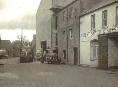
2 Kennedy's Factory

Related Images:
 

2010-10-28

Abercorn Factory: Derry Road c1911

Gallagher Egan Abercorn Factory
Looking Southeast along the Derry Rd | fullsize


View Modes
SEPIATOWN
WHATWASTHERE
BIRD'S EYE
View

Gourlie & Sons Shirtmaking Factory on the Derry Road opened in 1865. The site included a number of homes at the back of the factory known as Factory Row.

Gourleville Terrace, an additional group of houses to the rear of the factory (behind Factory Row), were named after William Gourlie & Son. In 1911 the new factory owner Paul Gallagher, lived at 3 Gourleville Terrace. An error in the 1911 census lists his address as Gourl(a)ville Terrace.

Timeline: Strabane Shirt Factories
Click on each event to get more information.


1848 Barrack Street factory established: owner James Kennedy
1865 Church Street factory established: owner Thomas Craig
1865 Derry Road factory established: owner William Gourlie & Son
1870 Barrack Street factory : steam power upgrade
1870s 6x factories in operation in Strabane
1874 Newton Road factory established: owner John Arthur
1875 Derry Road factory: new owners Masson, Kennedy & Co
1880 Derry Road factory: new owners Messrs & Pritchard
1882 Derry Road factory: new owners Stewart & McDonald
1888 Barrack Street factory: new owners Stapley & Smith

1901 Derry Road factory: new owners Stewart & Keady
1901 Barrack Street: James Kennedy dies
1911 Derry Road factory: new owners Gallagher and Egan
1930 Pallidrome Factory established: Cooper & Lawson
1937 Mourne Manufacturing Company established: Railway Street
Download full timeline: shirt-factories.csv


Cropped letter-head of Stewart & McDonald - owners of the Abercorn Factory 1882-1901: addressed from the Glasgow factory at 146 Argyle Street dated 1901.

Cropped letter-head Stewart & McDonald: addressed from the factory at 5 Buchanan Street, dated 1901


Related Documents:
Strabane Factories
(by Mr CurlyHill)
1 Porters
2 Gallaghers
3 Kennedys
4 Other Factories

2010-09-18

Abercorn Square c1907 - New Street

New Street 1907
Looking NW | fullsize
Tinted collotype published by Valentine Dublin (divided-back, 'low harp' logo in red ink)

View Modes
SEPIATOWN
WHATWASTHERE
BIRD'S EYE
View

Although the road is now part of Abercorn Square, a 1799 town plan sketch names this location New Road; placing a then virtual New Street 200 yard (approx) NE of this location. However, that virtual New Street was not to be. Instead, New Road became New Street and then became part of Abercorn Square shortly after 1901.

New Street is listed in the census of 1901, but not in 1911.

 
Poster: Quinn Brothers Saddlers c1910

Related Images:
 

2010-06-05

E Gallagher Ltd and Town Hall c1920

E Gallagher upper main street
Looking West from the Town Hall | fullsize

View Modes
SEPIATOWN
WHATWASTHERE
BIRD'S EYE
View

Edward Gallagher: 1901 1911 census.

  • 1869: Edward opens the drapery store.
  • 1884: Town Commissioner. Chairman of the Volunteer Fire Brigade.
    President of the St Eugene's Catholic Temperance Society.
  • 1904: As chairman of the Urban Council, Mr Gallagher was partially responsible for the expensive, and consequently controversial, town hall refurbishment 1904.
  • 1905: Gallagher re-elected by narrow margin.
  • 1906: Mr Gallagher decides not to run for re-election.
  • 1907: Eugene Conroy of the House League becomes chairman of the council
Newspaper Article
The Irish Canadian 5th Jun 1884 page 8 
- James Kennedy was the first Caltholic man in Strabane's history to be appointed to the position of Justice of the Peace c1882. Soon after this, the position was taken up by other Catholics including Mr Gallagher. Edward was also to replace Mr Kennedy as Town Commissioner by 1884.

Related Documents:  Strabane Factories (by Mr CurlyHill)
1 Gallaghers

2010-05-29

Town Hall

Town Hall 1930 - 1959 Upper Main Street
Looking Northwest along Upper Main Street c1940 | fullscreen

View on WhatWasThere

Postcard franked:  20 JNE 52

2010-05-17

Smyth & Sons - Canal St (1865-1980)

Robert Smyth & Sons Strabane
Looking Northeast along Canal Street | fullscreen

View Modes
SEPIATOWN
WHATWASTHERE
BIRD'S EYE
View

In 1865 Robert Smyth founded a mill in Strabane at the Canal Basin. Initially Smyths Mill produced 'Cookquick' Porridge Oats and animal feed. From the 1920s the mill concentrated on producing animal feed compounds up until its closure in 1980.

After partition, Smyths purchased an old flax mill in Ballindrait and named it Swilly Valley Mills. In 1995 Donegal Creameries purchased it. That mill was in production until 2000 when a fire destroyed the site. Daleside Mill was purchased soon after and production continues today under the name Smyths Daleside Animal Feeds.