Looking SouthEast along Dock Street | fullsize
View Larger Map
SEPIATOWN
|
WHATWASTHERE
|
BIRD'S EYE
|
|---|---|---|
| View | ||
Spires left to right:
o Church of the Immaculate Conception
o Christ Church
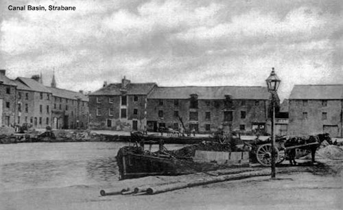
- 1796: Strabane canal is completed.
- 1962: Although the canal's official closing date was 1962, it had fallen into disuse as far back as the 1930s.
Related Video:
Photogrammetry test on a single image (post 1932). [Accuracy rate is low] Now that I have the 1905 Ordnance Survey map, higher resolution satellite imagery of the area, and a few more photos of the canal, I may take another stab at this someday.
Related Images:

No comments:
Post a Comment