 If you wish to inspect or alter the imagery, a file in KMZ format is now available for download
To use: open the file inside Google Earth.
If you wish to inspect or alter the imagery, a file in KMZ format is now available for downloadIf you wish to inspect or alter the path data used in the flyover, a file in KMZ format is now available for downloadReport, Robert Stephenson and Alexander M Ross, London 18 August 1845, with report of the first General Meeting of the Londonderry & Enniskillen Railway, The Railway Times, VIII, 30 August 1845, p. 1390. We have inspected the entire line, and have to report to you that much alteration is required to save expense, and to expedite the execution of the works very materially. We are informed that surveys were made in haste, and that Sir J. MacNeil, in the midst of his then pressing engagements, did not himself have time personally to go over the line.The line to Strabane should have been completed by September 1846 (L&ER General Meeting, Railway Times IX 29 Aug 1846), but allegations from shareholders of Ross's personal and financial involvement with the contractor James Leishman (1800-1884) slowed the project down. The railway station at Strabane opened months later in 1847. Perhaps wearied by the growing dissatisfaction and paranoia of parsimonious shareholder during the famine years, Stephenson and Ross withdrew from the project by January 1848. (The Railway Record V, 15 January 1848 pp56-57). It would take 6 more years to reach the terminus at Enniskillen.

View Online
|
Download BaseMap
|
Download EnlargEments
|
|---|---|---|
| Zoomit Views | KMZ for Google Earth | KMZ for Google Earth |
| Sheet 1 ∙ | City and County Londonderry | 6 Sections |
| Sheet 2 | Saint Johnstown - Templemore | 3 Sections |
| Sheet 3 | Porthall - Tullyowen | 7 Sections |
| Sheet 4 ∙ | Strabane town | 4 Sections |
| Sheet 5 | Breen - Milltown | 7 Sections |
| Sheet 6 ∙ | Newtown Stewart - Mulvin | 3 Sections |
| Sheet 7 | Beltan - Pubble | 11 Sections |
| Sheet 8 | Lislimnaghan - Castletown | 17 Sections |
| Sheet 9 ∙ | Omagh | 12 Sections |
| Sheet 10 | Mullawinny - Mullaghmore | 9 Sections |
| Sheet 11 | Drumskinny - Shanaragh | 8 Sections |
| Sheet 12 | Strangagummer - Esker | 9 Sections |
| Sheet 13 | Drummurry- Lisnahanna | 11 Sections |
| Sheet 14 | Aughaward - Salry | 9 Sections |
| Sheet 15 ∙ | Enniskillen | 9 Sections |
View Online
|
Download BaseMap
|
Download EnlargEments
|
|---|---|---|
| Zoomit Views | KMZ for Google Earth | KMZ for Google Earth |
| Part 1 | Lifford Common - Porthall | 6 Sections |
| Part 2 | Liggartown - Coneyburrow | 8 Sections |
| Part 3 | Trafalgar | 1 Section |
View Online
|
Download BaseMap
|
Download EnlargEments
|
|---|---|---|
| Zoomit Views | KMZ for Google Earth | KMZ for Google Earth |
| Sheet 1a | City of Londonderry Enlarged Plan | - |
| Swilly Branch | Port Lough - Whitehouse | 9 Sections |
Here is the download link to the Tenements section of the 1854 Map of Strabane. Since the Town Parks sections were drawn to a different scale they should be ignored in Google Earth. If you wish to inspect or alter the path data used in the flyover, a file in KMZ format is now available for downloadIf you wish to inspect or alter the track data within Google Earth, a GIS application or SatNav device, a file in KMZ format is now available for download.
 Here is the download link to the circa 2007 satellite imagery of Strabane in KMZ (Google Earth) format.Here is the download link to the circa 2007 satellite imagery of Strabane in KMZ (Google Earth) format.

SEPIATOWN | WHATWASTHERE | BIRD'S EYE |
|---|---|---|
| View | ||


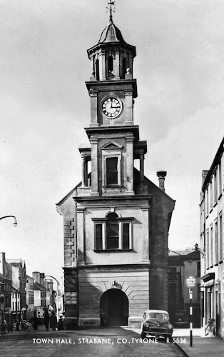
SEPIATOWN | WHATWASTHERE | BIRD'S EYE |
|---|---|---|
| View | ||


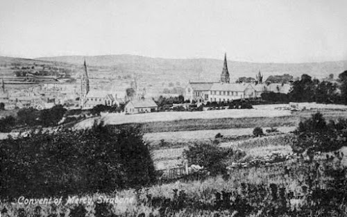
SEPIATOWN | WHATWASTHERE | BIRD'S EYE |
|---|---|---|
| View | ||


SEPIATOWN | WHATWASTHERE | BIRD'S EYE |
|---|---|---|
| View | ||
Quote from Christ Church website
Not sure of date, must be earlier than 1905 - water pump not visible (but may be hidden by houses) and lack of buildings on the Curley Hill!


 Here is the download link to the 1905 ordnance survey map of Strabane in KMZ (Google Earth) format. To use: open the file inside Google Earth..The Griffiths Valuation is perhaps the most important surviving genealogical data source on 19th century Ireland. Published between 1847 and 1864 and comprised of more than 300 volumes, it was the first full-scale valuation of all rateable property in Ireland.
| 1 | Fires and Fire Fighting in Strabane: 18th and 19th centuries Page 4 - Deaf and Dumb School Fire 1856 |
| 2 | 1858 Griffiths Valuation for Strabane Lower |


