2010-07-23

Electrification of Abercorn Sq, Fair day 1936

Fair Day 1930 Abercorn Square
Looking North from Market Street c1936. | fullsize

View Modes
SEPIATOWN
WHATWASTHERE
BIRD'S EYE
View


View on WhatWasThere

Photograph shows Abercorn Square connecting to the electricity supply.
Quinn Brothers Saddlers shop can be seen on the right.


John Quinn (Quinn Brothers Saddlers) c1950

Related Images:

2010-07-13

Bowling Green & Immaculate Conception Church

Bowling Green 1900-30
Looking Southeast near Church Street. c1910 | fullsize

View Modes
SEPIATOWN
WHATWASTHERE
BIRD'S EYE
View

Distant spire: Church of the Immaculate Conception 1895

Related Images:

2010-07-12

Bowling Green c1890

Bowling Green 1896
Looking Southeast from Church Street | fullsize

View Modes
SEPIATOWN
WHATWASTHERE
BIRD'S EYE
View

Christ Church shown on the right, opened in 1879.

Missing from this image is the Church of the Immaculate Conception which opened in 1895. The official 1896 date-stamp probably refers to the publishing/printing date of the postcard. The original photograph was captured sometime between 1880 and 1892.

Related Websites:
www.strabane.derry.anglican.org

Related Images:

2010-07-10

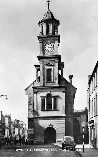
Town Hall circa 1950

Town Hall c1950
Looking Northwest from Upper Main Street | fullscreen

View Modes
SEPIATOWN
WHATWASTHERE
BIRD'S EYE
View

  • 1752: Market House opens
  • 1904: Expensive controversial renovations are complete.
  • 1972: Feb - Fire damages hall. [Boca Raton News - Feb 24, 1972]
  • 1972: Oct - 50 lb bomb destroys hall. [The Hour - Oct 10, 1972 - page 2]
    Although no one was injured in the destruction, many of town's historical records were lost forever.
As the 1904 controversy faded from memory, the building was eventually looked upon with affection by most Strabane residents. The loss of the hall in 1972 was mourned by people from all sections of the community.

On a positive note:- The hall was the hub to a network of narrow streets. The destruction in 1972 enabled the town centre to open up. By 1985 an area consisting of Townhall Street, Market Street, and Butcher Street was demolished. A new shopping centre and car park was built on the site.

Strabane hybrid map 1905-2010
1905 ordnance map superimposed on 2010 Google Maps.
(Google Map POI icons are inaccurate.)


Newspaper Article:
NY Times, August 11 1912
Town hall clock used for target practice.

Related Images:
 

2010-07-06

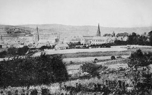
Convent of Mercy and Mount Kennedy

Sisters Of Mercy Convent Strabane
Looking Northwest from Springhill Park | fullscreen

View Modes
SEPIATOWN
WHATWASTHERE
BIRD'S EYE
View

Spires left to right:
o First Presbyterian 1872 - just on left edge of the postcard
o Church of the Immaculate Conception 1895
o Christ Church 1879 - in the far distance behind Mount Kennedy.
o Convent Chapel 1881
o Convent 1868

The small building near the middle of the photograph was called Mount Kennedy. It was the home of Mr James Kennedy; shirt manufacturer and a founder of the Convent of Mercy 1868. After Mr Kennedy's death 1901 the Sisters Of Mercy purchased the building and renamed it St. Anne's. In 1928 St Anne's became the nucleus of the original Convent Grammar School, until a new building was opened in the Curley Hill in 1968.

Convent of Mercy founders:
  • John Carlin, James Kennedy, Francis O Neill
  • Mother Catherine Atkinson (Sisters of Mercy, Navan)


Convent Timeline 1868-2009


Map 1905 Ordnance Survey: Convent and Church of the Immaculate Conception


Related Images: